Bhotekoshi flood | Supraglacial lake | GLOF | ICIMOD | Himalayan glacier melt
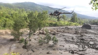
The catastrophic Bhotekoshi flood, which wreaked havoc in Rasuwa last Tuesday killing nine people and disrupting the country’s major trade route along with damaging hydropower plants of at least around 200 MW, is a consequence of the sudden draining of a previously unnoticed ‘supraglacial’ lake, according to the International Centre for Integrated Mountain Development (ICIMOD).
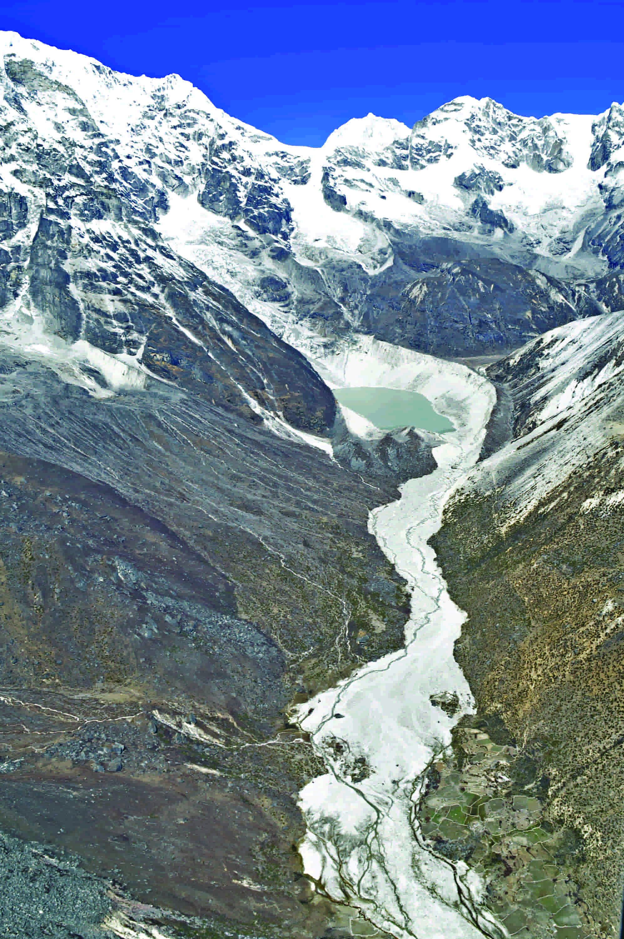
Preliminary satellite images and analysis by the ICIMOD reveals that the supraglacial lake began forming on Purepu glacier as a small pond towards the end of December 2024, which significantly increased in size by June 2025.
|
What are Supraglacial Lakes? According to ICIMOD, supraglacial lakes are small meltwater lakes that form on the debris-covered surfaces of glaciers. These temporary lakes may gradually expand and, at times, merge with each other to form larger lakes. These lakes are highly dynamic and can easily collapse under conditions of intense heat and heavy rainfall. |
According to the Department of Hydrology and Meteorology (DHM), a massive volume of water suddenly entered the Bhotekoshi River from the Tibet side at around 3 AM on Tuesday, causing a sudden rise in the river level around Rasuwa–Timure by approximately 3.5 metres.
While heavy rainfall was initially presumed as the cause of the flood, the department confirmed that there had been no significant rainfall on either side of Nepal or China at the time of the flood. Meteorological stations located in Kyangjin and Dhunche in Rasuwa recorded very minimal or no rainfall. Similarly, satellite data from the World Meteorological Organisation (WMO) indicated that there had been no rainfall in the upper catchment area of the Bhotekoshi River in the past 24 hours.
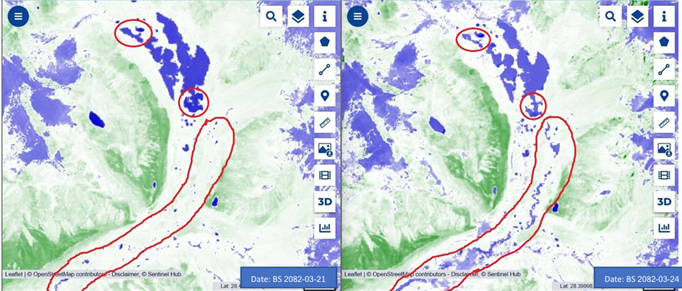
To further understand the cause and impact of the flood, the Department had earlier requested emergency satellite imagery from the Sentinel Asia platform. With the Bhotekoshi catchment area in Tibet containing numerous glaciers, the Department had already ruled out rainfall as the cause and reached a preliminary conclusion that the flood originated from a Glacial Lake Outburst.
The satellite images obtained from Sentinel-2 depict the Normalised Difference Water Index (NDWI), highlighting the formation of a glacial lake in the upper catchment of the Lende Khola, situated approximately 36 kilometres (kms) upstream from the Nepal–China border. Before the flood, the area of the lake was 0.75 square km, which shrunk to 0.6 square km after the flood, confirming the water discharge from the lake with a change in the lake’s surface area.
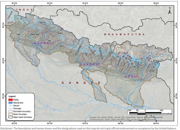
Previously, only lakes larger than 0.02 square km were considered at risk, and moraine-dammed lakes were prioritised due to their instability. Nepal has 21 such potentially dangerous lakes, according to a joint report by ICIMOD and the UNDP, which identifies high-risk lakes across the Koshi, Gandaki, and Karnali river basins.
On Tuesday, another flash flood struck Chumjung stream in Chhoser, Lomanthang Rural Municipality-4. The flood swept away six bridges in the village. With no rainfall reported in the area during the incident, glacial melt is believed to be the likely cause.
The ICIMOD has termed the occurrence of these two glacial-origin floods that occurred within a 24-hour period as unprecedented, further estimating that by the end of this century, the risk of glacial lake outburst floods (GLOFs) in the Hindu Kush–Himalaya region may increase threefold.
However, according to ICIMOD experts, some smaller or hidden lakes, whose existence was previously unknown, have now become sources of destruction. The recent flood events have been caused by the bursting of newly formed, ice-dammed supraglacial lakes.
These glacial-origin floods carrying debris-laden water are more destructive than normal floods. The 2016 Bhotekoshi flood and the 2024 Thame (Everest region) flash flood incident underscore a growing trend of such events, with floods increasingly mixed with large volumes of sediment and debris, causing severe damage downstream.
Read More Stories

NEPSE falls nearly 75 points as market sentiment wavers
The stock market was unable to maintain the gains seen on Tuesday, slipping...

India has begun its long-delayed population census. Here's why it matters
India has begun the worlds largest national population count, which could reshape welfare...

The United Nations has called on Israel to repeal a law passed by...

Business + Finance + Economy + Tech + Environment + Nepal & South Asia + In-depth Analysis + News + Investigation + Research + Expert Opinion + Anatomy of Complex Issues.